Cabin Lake Fire Information
Southern Area Incident Management Gold Team
Hours of Operation: 7 a.m. – 7 p.m.
Aug. 21, 2018 10 a.m.
|
|
|


Serving Meeker and the White River Valley since 1885
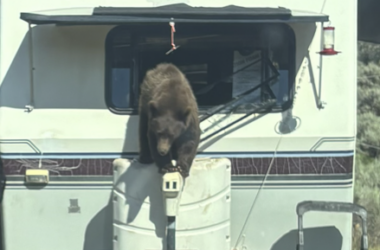 BEARY BAD MANNERS
July 22, 2026
BEARY BAD MANNERS
July 22, 2026
 PMC trauma manager honored by CDPHE, selected for committee
July 22, 2026
PMC trauma manager honored by CDPHE, selected for committee
July 22, 2026
|
|
|